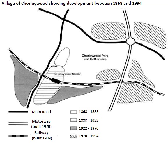
Chorleywood is a village near London whose population has increased steadily since the middle of the 19th century. The map below shows the development of the village. Write a report for a university lecturer describing the development of the village.

The diagram outlines the development that the Chorleywood village of London witnessed between 1868 and 1994. Overall, development works in this village were done in different periods and much of these constructions were done between 1970 and 1994. Interestingly, transportation facility defined the are of development in this village.
According to the diagram, the motor road was established in 1970 while the railway was built in 1909 in Chorleywood. Before 1900, only a portion of the village was developed and later (between 1883 and 1922) the station was built and some development works were finished. The area near the station was then improved and during the end of this construction, in 1970 to be precise, the motorway was completed. After 1970, the expansion process seemed accelerated and many areas of the village came under the renovation process. At the beginning of 20th century, the railway was built.
The land roads including the motorway, roads and railroads of this village connect almost all of the parts of the city and forms and hash like shape. The progress in this area had been done mostly based on the establishment of the transportation systems but the park and the golf course were placed in the middle of the village.
No comments:
Post a Comment